

In what promised to be a nice day which deteriorated quicker than a snowfall in a heat wave I went out to the north Pennines which was the heart of a vast lead mining industry from around 1500. It was very dull for most of the days with only a few fleeting glimpses of sunlight
Left to right.
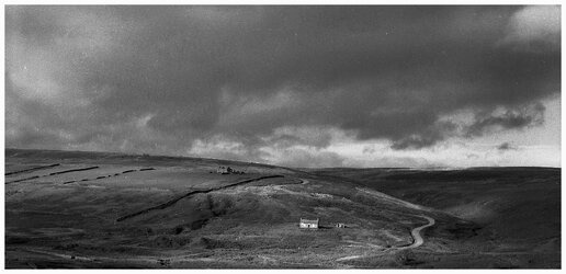
1. Near to the village of Edmundbyers are two unused farm building next to earthworks which is the trade mark of manual excavation to get at the lead deposits and seams just under the surface. They always show traces of mans endeavours.
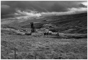
2. Grove Rake Mine which is the last remaining above surface signs of the deeper lead mines anywhere in the country to get at rich lead seams hundreds of feet down. There were two typical pit head workings and a mass of buildings which were vandalised for scrap but thankfully what is still there is protected against further demolition.
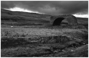
3. Further down the valley is a stone arch which formed a bridge over a narrow gauge railway and the Rookhope burn to take the smoke and other emissions away over the moors to a high spot close to a mile away to give a good flow of air to clear the fumes. Periodically the furnace would be allowed to die down and when cool enough children as young as 7-9 were employed to go through the flue to loosen lead fragments that had been deposited during the roasting of Galena to produce crude lead.
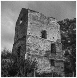
4. Shildon pump house which is still largely intact minus the pump and boiler was used to keep the lower levels of the mine clear of water. The pump was driven by a Newcomen engine with a massive piston 5'4" wide with a 6 foot stroke .
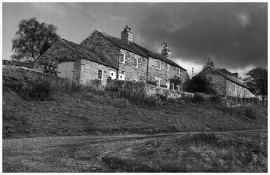
5. Just over the road from the engine house, are two rows of cottages which were provided by the owners to house their employees. They look very nice today but up to 4 families would have lived in each one so perhaps a little bit cramped.
(Foma100 film, yellow filter and Yashicamat 124g. Scanned direct from the negatives.
Left to right.
1. Near to the village of Edmundbyers are two unused farm building next to earthworks which is the trade mark of manual excavation to get at the lead deposits and seams just under the surface. They always show traces of mans endeavours.
2. Grove Rake Mine which is the last remaining above surface signs of the deeper lead mines anywhere in the country to get at rich lead seams hundreds of feet down. There were two typical pit head workings and a mass of buildings which were vandalised for scrap but thankfully what is still there is protected against further demolition.
3. Further down the valley is a stone arch which formed a bridge over a narrow gauge railway and the Rookhope burn to take the smoke and other emissions away over the moors to a high spot close to a mile away to give a good flow of air to clear the fumes. Periodically the furnace would be allowed to die down and when cool enough children as young as 7-9 were employed to go through the flue to loosen lead fragments that had been deposited during the roasting of Galena to produce crude lead.
4. Shildon pump house which is still largely intact minus the pump and boiler was used to keep the lower levels of the mine clear of water. The pump was driven by a Newcomen engine with a massive piston 5'4" wide with a 6 foot stroke .
5. Just over the road from the engine house, are two rows of cottages which were provided by the owners to house their employees. They look very nice today but up to 4 families would have lived in each one so perhaps a little bit cramped.
(Foma100 film, yellow filter and Yashicamat 124g. Scanned direct from the negatives.
Attachments
-
 Derelict farmhuse and unused cottage, Edmundbyers, Co Durham.jpg1.5 MB · Views: 7
 -
 Grove Rake lead Mine, Rookehope, North West Durham.jpg2.2 MB · Views: 7
 -
 Rookehope Lead Mine flue Bridge.jpg1.9 MB · Views: 6
 -
 Shildon Lead Mine Pump House, Blanchland, Northhumberland.jpg1.9 MB · Views: 6
 -
 Shildon Miners former cottages.jpg2 MB · Views: 7
Last edited: